Monday, April 2, 2012

Jackson Springs Park/ River Walk

The Ocmulgee River flows right through Macon. In fact, Macon is the dividing line between
Ocmulgee River
Jackson Springs Park

                The Jackson Springs Park part of a historic residential area, Shirley Hills, in Macon, GA. The park was designed to create a picturesque landscape. It also leads to the Ocmulgee River Greenway Trail.  The river flows south from Lake Jackson and its name derived from the language of the historic presence of the Mississippian Native Americans. 
                The river was used for navigation and transportation, trade, food. The Ocmulgee river walk is the only riverside trail in Middle Georgia.  It is a great recreational place for walking, biking, fishing and boating.     
.  


Wednesday, March 21, 2012

Community Gardens


A community garden can unite people and foster a sense of pride in the community.
The pros of the garden is that you can make your own compost. The starting investment will pay for its in the long run especially if you share tools.  The bills can be split between the people who volunteer.    
If you want to spend time alone in your garden to relax it can been hard when other people are too loud for your liking.  Not everyone uses the same techniques and this may be an issue, but it can be resolved.

Movie MegaFlood: Palouse River Canyon

 
The Palouse River Canyon is one of the 14 post mega ice age flood sites in the Scablands.  This includes Washington, Oregon, Idaho, and Montana.  The canyons were carved out and show evidence of the flood and the result we see today formed over thousands of years.

Monday, February 20, 2012

Igneous Rock: Obsidian


Obsidian is a a natural glass.  During volcanic eruptions the way in which the magma cools has an effect on the texture of igneous rocks.  Three factors that affect the crystal size include: (1) the rate at which the magma cools; (2) the amount of silica present; and (3) the amount of dissolved gases in the magma.

The glassy texture seen in obsidian is caused by rapid cooling.  The unordered ions are frozen before they could unite into an orderly crystalline structure. Obsidian was used by the native Americans to create cutting tools and arrowheads.

Monday, February 6, 2012

Minerals: Building Blocks of Rocks

This is the mineral feldspar
This is the mineral mica
This is the mineral galena
File:Quar...
This the mineral quartz


This is the mineral hornblende
 
This is the mineral calcite

Maps

This is an isarithmic map. It shows a certain phenomenon defined by smooth and continuous lines.

This is a choropleth map.  It shows statistical data for predefined regions


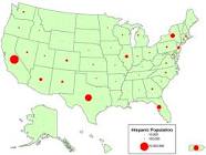
This is a proportional symbol map. The different size symbols represent data relative to each location. 

This is a dot density map. A dot can represent a certain number range, and placed in a certain location to show that phenomenon. 

This is a map I created based on how rural or urban  each county in Georgia  is.

Thursday, January 26, 2012

Map of Pancake Rocks,

The rock formation Pancake Rocks is located at Punakaiki West Coast,New Zealand. I have only traveled to Auckland and Rotorua which are located on the North island, but I would love to travel to the South island to visit this lovely geological site.

Pancake Rocks are irregular in shape and the formation of their layers, and are surrounded by blowholes. The rocks are limestone country, and each of the layers are a combination of resistant bands of limestone that are separated by thin, softer, mud-rich layers. This layering is common to limestone and it is called stylobedding.

The cause of stylobedding is believed not a natural formation,
but by compaction. The blowholes are also the contributing factor.
The erosion by the water, wind, and salt spray have all created the
pancake layering.